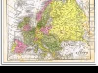
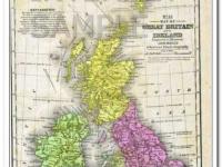
Vintage original 1882 Map of the BRITISH ISLES. Beautifully detailed of England, Wales, Ireland and Scotland. Has insets of The Channel Islands and The Shetland Isles in the upper right corner. This hand colored, steel engraved map was drawn by J. Wells of N.Y. and was engraved by Oliver J. Stewart of N.Y. Printed by A.S. Barnes and Company of NY and Chicago. This 127+ year old map would look sensational matted and framed! A true antique.
- SKU f905
Payment Methods


Shipping
USPS, FREE Shipping
Payment Policy
We accept major credit cards and PayPal.
Payment is due upon checkout..
Shipping Policy
Free Shipping. USPS First Class with Delivery Confirmation
All ads, catalogs, and maps are stored and shipped in an acid-free PVC sleeve with a stiff acid-free white backboard. Items are always stored and shipped flat, never rolled, folded or shipped in tubes.
Mailers are stamped ((( PHOTOS - DO NOT BEND ))).
We only ship to your 'confirmed' Paypal address.
All shipments will have USPS tracking information available via email and online.
We package all items for safe and secure arrival.
Domestic USA Shipping Only.
Sorry, No International Shipping at this time..
Return/Exchange Policy
Returns Not Accepted, unless grossly misrepresented.
Other Policies
Open 24 / 7
Please Login or Register first before asking a question.